George & Mostyn - Walking the GR10
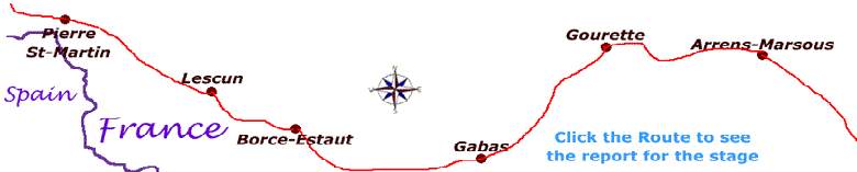
Stage 14 - Gabas to Gourette
Distance - 22.5km: Height gain 1468m: Height loss 1149m. Crossing the Corniche des Alhas, Lac d'Anglas, Hourquette d'Arre (2465 m).
Sunday, 22nd June 2008
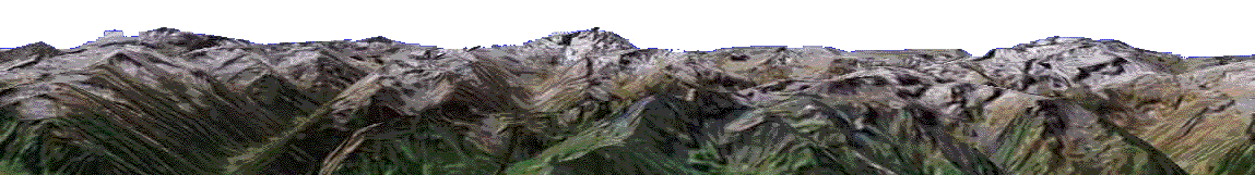
Mostyn:After breakfast, which had been left out for us, we began walking at 7.00 am. The first part was a gentle slope, gaining about 150 m. We had the option of continuing down the valley and having to climb back up or taking the Corniche Alhas, the sign read "Passage Vertigineuse" - roughly meaning a route that is so high it will make you dizzy. The Corniche was very narrow and about 500 m long. There was a vertical drop on one side. There was, however, a handrail along it, which made it far safer. At the end of the Corniche we had to cross a bridge and after a gentle stroll through the forest we began to climb up a very steep zig-zag path, gaining 500 m height. We emerged onto a plateau and steadily climbed up the edge of a valley with quite a large flat plane below us. On the other side of the valley was Le petit Train d'Artouste, which went up to the Pic de la Sagette (2031 m)


Climbing ever upwards we passed another valley, similar to the first, 500 ms higher up.
Then came a steep straight climb up a long ravine. We had to cross 4 fast flowing streams and negotiate paths across scree.
We met a couple coming down the ravine and we each watched one another cross the particularly difficult streams.
Crossing one particularly hazardous stream, Ian jumped across first and indicated to me where I should put my feet.
I threw caution to the wind and leapt across, only to career into Ian knocking him flying. We both ended up flat on our backs in fits of laughter.


There was a ridge above us, which looked like the summit, but we knew that it was a false one.
We had been passing snow since about 1700 m, but nothing to concern us.
Then, as we negotiated the aforementioned ridge, there was nothing but snow ahead.
We were quite taken aback as no one had mention that this was a possibility.
One of our guidebooks had vaguely mentioned the possibility of snow on the other side of the ridge.
If this was the case, just follow the tracks.
Of course we hadn't enquired about snow because we expected there to be adequate warning if there was any possibility.
We had three choices. 1) return the way we had come, which meant a round trip of 34 km, once again negotiating the treacherous streams; 2) descend to lower ground and camp in Ian's tent for the night; or 3) follow the tracks in the snow up to the Col Hourquette d'Arre. Fortunately Ian had experience of snow conditions because he had worked in Antarctica. We decided to take option 3) and carry on. Ian gave me a crash coarse in climbing, traversing and descending in snow. He took the lead and we literally kicked our way up the 150 m to the Col. As we were climbing I remember thinking "I hope it's not this bad on the other side." I then realised that the sun was on my back, which meant that the other side would have been in the shade and therefore there would be more snow.


On reaching the Col there was snow as far as the eye could see. We noticed three sets of footprints in the snow.
Out came the maps, guidebook and compass. We followed the route to the right as we knew that we needed to reach lac d'Anglas and it was in that direction.
Ian made a number of dummy survey walks to assess the snow conditions and to find a safe route down to the lake, which we could now see.
We traversed the large snowdrifts, always going down towards the lake and, where possible, used terra firma.
This was an unforgettable experience. I must admit that I was relieved to reach the lake.


We walked around the edge of the lake because the GR10 actually approached the lake from the other side.
We spotted one of the many signposts, giving us information about the area and the GR10 route, across a large steam.
There were two pieces of angle iron across the river so we laid them close together so that we could walk sideways across them, using a walking pole as a "third leg".
One of us steadied the makeshift bridge while the other traversed it. When we were both safely on the other side we studied the signpost, only to find that the GR10 re-crossed the river about 100m further along the bank.
This time we crossed using submerged stepping-stones.
The route down to Gourette was a difficult and narrow path. We were both very tired when we arrived but felt that we had really achieved something. Once in Gourette we found a bar and ordered a couple of lemonades each, never has a lemonade been more needed or tasted better. That evening we had our meal with four French walkers who were spending the weekend hiking. We watched the first half of the Spain vs Italy football match together. This had been a long day, 12.5 hours, 3.5 hours of which had been through the snow.